
Welcome to Multia!
Welcome to Multia! In the heart of Finland’s Lakeland lies Multia – the place of dark forests, in the middle of the most central Finland.
Are you without a nature tour, route, event or accommodation? You’re in the right place, because Visit Multia is there just for you.

Here you will also find maps of the Multia area and information about events, services and destinations. Welcome, we are waiting for you!
Multian Kunnantupa – Shop and information point
Multianraitti 1, 42600 MULTIA
tel. +358 40 301 6235
multiankunnantupa.nettisivu.org (in Finnish)
Information about Multia's attractions and tourist destinations, products and crafts from local entrepreneurs, as well as café services and the biggest and tastiest ice creams in the province!
Getting to Multia:
By car: We are in the middle of Finland – Keuruu 19 km, Jyväskylä 60 km, Ähtäri 53 km – see map below –
By plane: The nearest airport is in Tikkakoski (60 km).
By sea: Unable. We are an inland destination.
By train: The nearest railway stations are in Keuruu and Jyväskylä. Check VR's (national railway company) website.
By bus: You should check the bus connections on the Matkahuolto website

 Departure point from Multia centre to Keuruu 1 km, behind the Halli bridge. The route is part of the regional hiking network of Central Finland. The school path of the poet Einari Vuorela from Multia to Vuorela is approx. 8-9 km of varied terrain. If weather is dry, you can take the route using jogging shoes.
Additional information :
Retkipaikka.fi (Kukelinkyökki) (only in Finnish)
Multia’s leisure instructor (tel. +358 40 301 6230)
Multia tourist info (tel. +358 40 301 6235).
Map


The home of Einari Vuorela
 The nature trail is located in the popular Palsankoski rapids fishing area 10.5 km from Multia centre in the direction of Karstula. The length of the route is only 1.5 km, so it is very suitable pause for a car ride. Although the route is short, it goes around through a wide range of terrain types. There are large height differences on the route, yet it is relatively easy to go.
Additional information:
Retkipaikka.fi (only in Finnish)
Multia tourist info (tel. +358 40 301 6235).
Map

© Maanmittauslaitos, lupa nro 491/MYY/03
 The Joensuonkangas nature reserve in Sahrajärvi, Multia is a representative sample of untouched Finnish nature. The route is a bit over 2 kms and is easy to go. Some natural specialities are marked with signs.
The route starts at address Joensuontie 618 (some of the GPS navigators know the road as Hoikantie).
More information:
Jalkaisin kävely- ja retkeilyblogi (in Finnish)
Multia tourist info (tel. +358 40 301 6235).
Map

© Maanmittauslaitos, lupa nro 491/MYY/03
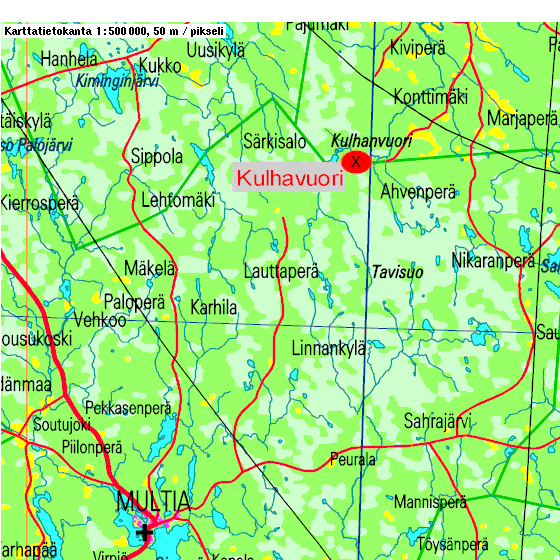
 The Kulhanvuori area is located on the border of the municipalities of Multia and Saarijärvi. The area represents diverse and rich nature. There are cliffs, canyons, black ponds, pristine swamps, etc. The area is now a nature reserve, so moving there takes place by marked routes.
Guidance: Follow the "Kulhanvuori" signs, you can find first of them on Multia-Uurainen road approx. 6 kms from Multia centre. The area is a part of Natura 2000 EU project.
Additional information:
Luontoon.fi (in Finnish)
Multia tourist info (tel. +358 40 301 6235).
Map
© Maanmittauslaitos, lupa nro 491/MYY/03
Surrounded by steep walls, a gorge lake on the border of Multia and Petäjävesi. The place is suitable for family hiking because you can get a few hundred meters from the destination by car.
How to get there: 14 km from Multia centre in the direction of Uurainen, followed by Petäjävesi road 4 km.
Additional information:
Retkipaikka.fi (in Finnish)
Multia tourist info (tel. +358 40 301 6235).

Map

© Maanmittauslaitos, lupa nro 491/MYY/03
 The length of the route is 34 km.
Multia settlement is recorded in the records in 1564 and in the same century the Nikara wilderness house was built in Nikaranperä.
The first inhabitants settled in the Nikara area in the late 1552s. At the time, there were no transport connections in the vast wilderness, except for water bodies. Residents cleared and planned a route towards Multia and Keuruu, where the first church was built in 1628.
Before that, from time to time the people of Multia and Keuruu visited the Ruovesi church to hear preaching and meet each others. The distance between Nikara and Ruovesi was more than 100 kilometres in its direction. Another church in Keuruu was built in 1656 and the third in 1738, which still stands in its place. Multia got it’s own church in 1796, and thus the trip of the Nikara people to church was greatly reduced. On the holy days, when Multia had no priest, they still went to church in Keuruu.
The route went from Nikara house to Kallionikara, where Kangasjärvi provided an ideal place to stop. There have been found to have wooden marks and carvings on trees, but unfortunately these trees have been cut down. The journey continued from Kangasjärvi towards Peuralanperä. Between them, Pienimäki served as a place to stay for travellers. After that, next destinations were Tiihala, Uitamo and Vilhula, through which they reached Multia church. The roadmakers at the time cleared and build the route through boreal forests and marshes. Bridges had been built over the rivers and marshes crossed along duckboards. On the narrow Uitamo lake, roadmakers build a ford and later a bridge was made over it.
In autumn 2005, a group of people representing Multia-Seura, Nikara village association, the Pienimäki family and Finnish Environmental Institute gathered together to coordinate the restoration of the route. The first part of the route, Nikara-Pienimäki (20 km), was decided to be cleared and the route was completed step by step at the end of the summer of 2009. A valuable church road was thus made available to wanderers.
The site has also been presented on Retkipaikka.fi (in Finnish only).
Map

 For more information, please contact the Kunnantupa Info Point at tel. +358 40 301 6235 and luontoon.fi (also in English) and retkipaikka.fi (only in Finnish) websites.
The description of the sites has been partly based on Risto Sulkava and Pekka Sulkava's guide to valuable natural sites in Multia from 1992.
When moving around in nature, remember everyone's rights (formerly everyman's rights) and outdoor etiquette.
Hallinmäki
Significance: Outdoor activities and recreation area
Description: A partially managed area with a 100-year-old large spruce forest. The area has a few creek valleys where eagle's-winged primroses grow. In Hallinmäki, a so-called ancient beach is visible about 160 m above sea level. The stone belt was formed about 9,600 years ago.
Other: The area has an illuminated ski trail, a fixed-point network, and a marked trail to Vuorela runs over the hill.
Hangaslahti
Significance: Suitable for recreational use
Description: The rugged shores of the southern end of Lake Sinervä. The shores have diverse flora. The so-called Poet's Path also runs through the area, starting point is approximately 1 km from Multia centre in the direction of Keuruu.
Other: The route is marked with blue paint marks to Hangaslahti and the Poet's Path with "Runoilijan polku" signs. No campfires.
Hännättömänjoki – Soutujoki, Palsankoski
Significance: A nationally significant old-growth forest conservation area, which is important for nature, recreation and fishing tourists.
Description: A diverse and valuable natural entity. Geologically, the area is the most significant in Multia. The area's nature is excellent for hikers due to its diversity.
Other: There is also a lean-to and a reservation hut in the rapids fishing area.
Isojärvi Outdoor and Horseback Riding Trail
The total length is 18 km. The trail can also be walked in parts. For example, the distance around Isojärvi is about 7 km. The starting point can be, for example, the Isojärvi Youth Association building. In the yard of the clubhouse there is a toilet, a lean-to and a horse barrier. Another possible starting point is the Haravakallio road junction, which is marked with a P on the map. There is also a lean-to at the junction (the sign is missing from the map). The trail is marked with yellow signs with blue arrows. Yellow signs have also been painted on the trees.
Riders NOTE: Coarse gravel has been driven between the Haravakallio road junction and Raatemaja.
Joensuonkangas
Significance: A place to get to know the original Finnish nature.
Description: A protected wilderness area with hundreds of years old Scots pines. The area is an important monument to Multia's past.
Other: A nature trail of about 3 km runs through the area, along which several natural features are marked. No campfires are allowed.
Kaleton swamp (Iso-Kaleton)
Significance: Hiking destination for those who are familiar with the swamp nature.
Description: A protected, almost overgrown pond. The springs in the area are favorable breeding grounds for, among others, toads and common frogs.
Other: No campfires. Birdwatching tower. There is no signpost for the swamp.
Kiiskilänmäki / observation tower
Significance: Hiking destination
Description: The highest point in southern and central Finland (268.8 m above sea level).
Other: Lean-to. Driving directions: 23 km from Multia centre, first along Uurainen road and then Pajupuro road.
Please note: the tower is currently under renovation and out of use.
The Poet's Home Vuorela (The Poet's Path)
Significance: A cultural tourist destination. It is also beautiful in its scenery.
Description: The birthplace of Einari Vuorela, located along the Central Finland Provincial Hiking Network. The "Poet's Path" is marked from Multia to Vuorela.
Other: Varpu-Liisa Vuorela is responsible for Vuorela. The Einari Vuorela Society organizes guided hikes along the Poet's Path to Vuorela in the summer.
Kohtamatkanneva
Significance: For bird enthusiasts and cultural tourists.
Description: A fine, undrained bog with marshy edges. Kaakkolampi in the middle of the bog has a rich birdlife. Among others, the hayloft, the tufted wagtail and the crane. Hay barns and haystacks have survived there, reminiscent of the old days of hay harvesting from the bogs.
Other: No campfire site. There are no signs to the bog.
Koukkusuo
Significance: For those who are familiar with the swamp landscape.
Description: Undrained bog and a small overgrown pond. On the edge of the bog there is a motorcycle club lean-to and a toilet.
Ajo-ohje: 5.5 km on Uuraistentie, 13 km on Sipiläntie.
Kukelinkyökki
Significance: A stopover for hikers on the Poet's Path.
Description: A small cave near Päijänteenmäki. According to memoirs, a man named Kukeli, who was on the run from a murder, lived in the cave. The man's mother brought food for her son to "Kukelinkyökki".
Other: No place to make a campfire. Guidance from the Poet's Path.
Kulhanvuori
Significance: Nationally significant hiking and recreation area.
Description: Old-growth forest conservation area. Syväoja hiking trail. Pirttipuro mill also nearby. Very diverse nature complex.
Other: Possibility to make a campfire. 3 km nature trail in the area.
Kurenkoski
Significance: For recreational and fishing tourists.
Description: A rapid popular with fishing tourists, with a lean-to along it. The dipper nests in the rapids and you can also meet an otter there.
Other: Campfire site and lean-to.
Lampuodinsuo
Significance: An area of national significance.
Description: The bog, which is part of the national bog protection program, is an oasis bog formed by many types of bogs. The bog is located at the highest point of Central Finland's bogs (234 m). Lampuodinsuo, combined with Lauttajärvi, Kangasjärvenkangas and the Kulha area, is excellent for relatively demanding wilderness hiking.
Other: There are currently no campfire sites in the area and there are no signs for the area.
Lauttajärvi
Merkitys: Suitable for wilderness hiking, if you are looking for a real wilderness experience.
Description: A beautiful, rugged wilderness lake in the largest uninhabited area of Central Finland. You can find several bird species rare in inland waters at Lauttajärvi.
Other: No campfire site. There are currently no signs for the lake.
Aukusti Mustonen's stone
Significance: For nature hikers.
Description: Two huge boulders on top of each other. At the beginning of the 20th century, the owner of Korpela, Aukusti Mustonen, bought the stones from Nestori Putkimäki for two silver marks, with the intention of building a stone barn in Korpela with them. However, the barn was not built, because Mustonen sold the Korpela farm and bought the Pirttimäki house instead.
Muuta: No campfire site. No signs.
Pirttipuro mill
Significance: Recreational and hiking destination.
Description: Old protected mill. A small dance stage has been built in the area by the Konttimäki Village Committee. A path is marked from the mill to Kulhavuori.
Other: The mill has a campfire ring for making a fire. Guidance to the site from the road.
Riuttakoski
Significance: For nature and recreational tourists.
Description: The impressive rapids and old drift channel make Riuttakoski valuable. Several plant species grow around the rapids, including valerian, wintergreen, wild rose, pansy, beach mint, etc. Several dippers also winter in the rapids.
Other: Campfire site. There is a lean-to on the bank of the rapids.
Ropottimaa trenches
Significance: Historical site.
Description: Trenches dug in 1916-1917.
Other: Signposts to the site from main road 58.
Rympsylänpuro
Significance: Local recreation area for nature lovers.
Description: Natural stream bank, where flying squirrels, among others, nest. The stream is an integral part of the Uitamonkoski Mill Museum area. There was also a shingle slicer in the stream at one time.
Other: Signposted from the Multia-Uurainen road. No campfire site.
Salmijärvi-Pääkkö
Significance: Excellent area for wilderness hiking.
Description: Long and narrow wilderness lake area. Natural bogs and pine forests. A special feature at the southern end of Salmijärvi is a large stone ruin formed from shifting boulders.
Other: Campfire site on the shore of Pääkkö. However, caution should be exercised when handling fire. There are no marked trails in the area for the time being.
Saunalehto
Significance: For those who want to explore untouched nature.
Description: A primeval forest area almost the size of Joensuunkangas, with many dead trees and shield pines. The area is home to, among others, marten and forest vole.
Other: No campfire site. There are no signs to the site.
Syrjäharju
Significance: For nature tourists
Description: A magnificent ridge formation, the best parts of which are on the Petäjävesi municipality side.
Other: No campfire site. No signs.
Uitamokoski Mill Museum
Significance: The only mill museum in Central Finland.
Description: A museum owned by the Multia Seura ry. The history of the mill dates back to 1864, inaugurated as a museum in 1968.
Other: The mill building is open for free tours in June-September.
Directions: From Multia centre, 2.5 km in the direction of Uurainen, signpost on the road.
Valkeisenjärvi lake
Significance: For bird enthusiasts
Description: The lake/swamp, which is part of the bird water protection program, is the most significant bird lake in Multia. The lake and its shores have a diverse selection of birds and plants. A birdwatching tower has been built near the lake.
Other: No campfire site. The birdwatching tower can be seen from Kukontie road.
Vesilahti swamp
Significance: A nationally valuable area for those exploring the nature of the swamp.
Description: A swamp, which is very watery in places, which is part of the mire protection program. The swamp is home to a very rich birdlife and is also important as a recreational area and berry-picking swamp.
Other: No campfire site. The instructions given for the protected area must be followed in the swamp.
Multia's views are beautified by numerous clear-water lakes, ponds and rivers with more than thirty rapids. Come and experience Multia's good fishing spots.
Please note: external websites are in Finnish only unless otherwise stated.
Multia's cooperative fishing permits for 2025 can be obtained from the OstaLuvat.fi website (fishing units, fishing instructions, payment). The website also contains a map of the lakes to which the permits apply. There is also a more accurate version of the map.
However, fishing in the area of the Multia cooperative is prohibited in the entire area of Multianjoki (e.g. Kurenkoski, Riuttakoski), Myllypuro (the stream that flows from Termity to Sinervää), Sarajoki and Saikanjoki. The basis for the ban is to improve the living conditions of the trout.
More information about rapids fishing and obtaining a fishing permit as well as fishing spots can also be found at http://www.palsankoski.fi.
Rapid fishing destinations
The Palsankoski area is a three-kilometer-long fishing area surrounded by three rapids.
The rapids were restored in the summer of 1996.
Game fish: trout, rainbow trout and grayling
The area has a lean-to, a campfire and smoking area, a toilet and a cottage for rent.
Game fish: trout, rainbow trout, lake salmon and grayling
Both Kurenkoski and Riuttakoski have a lean-to and a campfire site.
Villinkoski (also in English)
Multianjoki

Shut down your laptop and come have fun here at Multia!
At Multia, you can spend your free time on the water, in forests, at events or just relaxing. For the more active, there is summer jogging or other exercise. There are swimming spots, ice cream and frosty pint too!
When autumn comes, the forests are full of mushrooms and berries, or you can just enjoy the fall on lakes or forest paths. Hunters can find great experiences in Multia's vast wilderness. Traditional Finnish winter can also be found at Multia! In winter, after the lakes freeze, a snowmobile route runs from south to north through Multia, and snowmobiling can also be enjoyed in your free time on several local routes and on the ice of the lakes.
If you are into nature photography, you may be surprised at how many wonderful destinations you can find here.
Multia's library (website in Finnish only) offers reading and interesting research for rainy days and other times. And if work is pressing on or other things need to be done online, they can also be taken care of using public workstations.
In winter, Multia has beautiful snowy forests and numerous lakes for outdoor exercise. There are several groomed trails in the terrain and on the ice of the lakes, trail info can be found at ladulle.fi. In early spring, there is also a traditional Keuruu-Multia ski trip (in Finnish only) with accompanying events.
Frisbeegolf
 Siltalammintie 5
Multia frisbeegolf course (only in Finnish)
Multia has versatile forest track with 22 fairways. There are also some height differences on the track, which bring variability and challenge to the fairways.
The total length of the fairways is 2 km 200 m. You can also choose a shorter family route. In the area there is a log cabin, a campfire site and a toilet. In winter, there is a illuminated ski track and a skating track in the same area. Frisbee is also popular as a winter sport (be careful when crossing tracks).

Lisäksi urheilukenttää (Kisaraitti 2) kiertää lyhyempi, 7-väyläinen rata.
Kayaking
 Multia's kayaking routes run in the area of Sinervä, Iso Multiajärvi and Pieni Multiajärvi, as well as Kissalahti.
You can paddle a 26 km route near the beaches, and there are eight "self-help" landing spots along it.

Rauhanpuisto
Pappilantie 5
Outdoor fitness area, 6 different fitness equipment.

Multia fitness stairs
Multianraitti 4
Multkynnäs, fitness stairs in the center of Multia The stairs are at the apartment end of the municipal office on the other side of the road.
You can leave your car in the yard of the municipal office, for example. These 36 stairs were introduced in the fall of 2022.

Instructions for users
- consider other users
- please protect the spikes of the walking sticks with rubber covers
- don't do stair training together with the dog
- do not descend the stairs with a ladder, sled, etc.
The stairs may be slippery. No winter maintenance!
Let's keep the stairs in order together.
Pump track -rata
 Junttilantie 2
The Multia pump track was completed in early autumn 2024 with the help of the Leader Vesuri development project.
The track is located in the yard area of Sinervä school. It is designed for users of all ages. The rolling and winding, hilly track provides thrilling speed fun for bikes, scooters, skateboards, roller skates, and even hobby horses. We recommend the use of appropriate protective helmets on the track.
Gym and Sinerväsali
Pihlajatie 1
You can buy access control pass for the gym and Sinerväsali from Multia library (Pihlajatie 1) within service hours (mondays 10-17, tuesday-thusrday 10-16).
| 10 times | 3 mos | 6 mos | 12 mos |
Adults | 40€ | 50€ | 60€ | 105€ |
Family card | – | 75€ | 105€ | 180€ |
Pensioner, unemployed, students 12-24 years | 20€ | 30€ | 50€ | 70€ |
More detailed information about the available shifts can be found at Julius booking system.
You can also buy more value to your gym card yourself! Register to the WebKulkuri service using this link and you can buy value to your card yourself. If you don't have a pass yet, you still can register and pick up the card from the library later. Please note that the library staff must first activate new registrations in the WebKulkuri system, after which you can buy value for the access pass!
In the library, you can also pay for sports and cultural services with Epassi.
Multian naisvoimistelijat organizes sports events and gymnastic exercises also in the summer.
The sports of MultiAnts sports club are e.g. futsal, floorball and soccer.
Accommodation


Multianniemi summer cottages
Eija and Olavi Pienimäki
Pappilantie 7
42600 MULTIA
+358 400 541 674
pienimaki@hotmail.com

Multianraitti 11
42600 Multia
tel. +358 400 237 373
Facebook
multimotelli@gmail.com
Lunch at weekdays mo-fr 11.00-13.30
Catering services
Accommodation


Restaurants

Multi-Motelli
Restaurant, A-license
Multianraitti 11
42600 MULTIA
+358 400 237 373
multimotelli@gmail.com
Cafe Korsu
Keskustie 20
42600 Multia
+358 50 466 7111
korsubaari@gmail.com
Facebook
Camping Sinervä
Summer cafe & restaurant
Leiritie 12
42600 Multia
+358 400 241 622
info@campingsinerva.fi
Facebook
Sahralinna summer cafe
On summer weekends from Midsummer until the end of July
Sahralinna village and youth association
Sahrajärventie 16
42660 Sahrajärvi
Facebook
Catering services
Tmi Leipurin Herkkukulma
Humalamäentie 243
43430 Väätäiskylä
+358 40 537 3015
Vanha Väätänen
Satu Väätänen-Rinne
Väätäsentie 16
43430 Väätäiskylä
0400 565 398
vanhavaatanen@pp.inet.fi
vanhavaatanen.com
Kiiskilänmäki
An observation tower was completed on Kiiskilänmäki, the highest point in southern and central Finland (268.8 m) in the summer of 2004. There is also a hut and a lean-to near the tower. You can find the destination at Sahrajärventie 725, Multia. You can find more information on Multian kylät or Retkipaikka pages (in Finnish only).
Multia Loviisa Charlotta church
The church was completed in 1796 and the church was consecrated as Loviisa Charlotta church on 11 December 1796. Loviisa Charlotta was the fiancee of the then Crown Prince of Sweden-Finland, Kustaa Aadolf. You can find more information on the parish's website (in Finnish only).
Homeland museum
In the center of Multia there is also a homeland museum. The museum started its operations in 1957 in Multia's granary and in 1959, when the granary turned one hundred years old, it was decided to be closed and donated to Multia-Seura as a museum, more information on Multian kylät (in Finnish only).
Uitamokoski mill museum
Central Finland's only mill museum is in Uitamonkoski, 2.5 kilometers from the center of Multia along Uuraistentie.
The miller Kaarle Virtanen bought the old mill in Uitamonkoski and the mill plot belonging to it in 1881 and built a new customs mill by 1888. Today, the mill is owned by Multia-Seura.
Multia-Seura restored the mill and it was inaugurated as a museum in 1968. More about the history of the mill on Multian kylät (in Finnish only).
